|
|
|
|
|
FROM THE MAP TO THE NETS/ACTUATION/HAPPY HOUR PROJECT/PEDAOLONA |
| This translation is a draft by students of Maggiolini High School from Parabiago |
|
PLIS
Mills' Park
(Milan - Italy) Attachements
- cycling
mobility Alto Milanese plan
- Mill's park document about the soft mobility for EXPO 2015 - main street Nerviano-Valle Olona itinerary on Google maps -Kmz layout to modify on Google earth - Legnano-Rho stetch MI-LU itinerary on google maps - LET EXPO n. 2 itinerary on google maps -cycling layout chart which have been made  Related
pages
Co-financing:
Mill's Park 
Cariplo foundation MILAN EXPO 2015 REGION LOMBARDY RIVER'S TREATY Share on Facebook Collaborators: Translations in English: Aurora Donnaloia, Tatiana Martinez in Spanish: Simone Schipani Web Site: Andrea Loperfido |
PARTICIPATION>LANDSCAPE CENSUS>PLANNING>ACTUATION THE OLONA RIVER' S TREATY 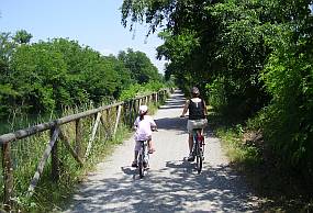 Happy
Hour-Project
PEDAOLONA Together we are going to
talk about the soft mobility to bring
back people to Olona river. There
are 5 projects: work
with: December 2016. In the view of the realization of the guide map of the cycle and pedestrian routes of the Mills Park, we invite you to collaborate to the Open Street Cycle Map Project! If you aren't able to modify the map, point out correction or addition! OpenCycleMap.org - the OpenStreetMap Cycle MapLAST
MEETING Associations which operate
for the soft mobility are particularly
invited. The ones who didn???t come to
the meetings can send us an e-mail
with their project proposals.
REALIZED PLANNING ACTIVITIES REPORT FIRST MEETING A little floral (black
locust flowers are out of season)
toast (offered by Diego) has gladden the
PEDAoLONA
participants ??? soft mobility
along Olona river on 19/05/2014
(Legambiente of Parabiago and Nerviano,
LIPU of Parabiago, Parabiago and
Legnano???s municipality, US Legnanese,
Confcommercio of Legnano, 1001 MI.SAV,
Assesempione, Turismosempione). 1.according to the
subsidiarity principle that is about the
collaboration and sharing between equals
which put resources in the net and take
the responsibility to reach a shared aim
which is of public interest.
2. in
the SHORT PERIOD
3. favoring the rural roads net
for a greater contact of the users with
nature
In
particular we have discussed about the
document which Mills' Park and
Parabiago???s municipality have edited as
leaders of soft
mobility projects in the field of
Altomilanese coordination for EXPO 2015. The shared aim between participants is to achieve in a short time the itineraries (not necessary cycling lanes) feasible with safety, along the eight main guidelines. To be concrete and face the subject also in view of Mills day 2014 on
Linked
to this layouts there also are: 1.The
itinerary Milano-Lugano stretch
Rho-Legnano which
is going to be made by feet on the
occasion of Mills
day 2014
with Trekking Italy:
- See the itinerary on Google maps - Download the Kmz layout which may have to be modified on Google earth for observations, integrations and modifications 2.
The itinerary
LET EXPO N. 2
- See
the itinerary on Google maps
That itinerary is the sum of 4 main roads of cycling mobility plan Alto Milanese. 3.The great work made by Busto Garolfo e co. of united cycling lanes system Alto Milanese -See the cycling layout chart that have been made B. DECISIONS
Red
and discussed the document and the
Nerviano-Valle Olona layouts the
participants decide:
0. to make in the short period the Nerviano-valle Olona layout favoring the dirty roads and passing some obstacles such as Starqu?? mill stretch, the one of the way near Empyre discotheque and the one between the Foppa and San Vittore Olona???s bank. 1. to read carefully the document and send to the Mill???s Park possible observations 2. cycle societies will make the itinerary layout go until Castellanza with the indication of the critical things to solve, billboards included 3. it is going to be edited the draft copy of the temporary indication billboard 4. it is going to be put the temporary billboards to try on occasion of Mills day 5. there are going to be taken contacts with the bordering field owners of Empyre discotheque. |


