|
|
|
|
|
FROM THE MAP TO THE
NET / LANDSCAPE CENSUS |
| This translation is a draft by students of Maggiolini High School from Parabiago |
  
 A participated path for the qualification of the periurban landscape along Olona river. Linked
Pages:
Co-financial Backers:
Mills park 
Cariplo foundation Share on Facebook Collaborators: Translation in English: Francesca Loiacono, Aurora Donnaloia, Tatiana Martinez in Spanish: Simone Schipani Web Site: Andrea Loperfido |
PARTICIPATION>LANDSCAPE
CENSUS>PLANNING>ACTUATION OF OLONA RIVER'S TREATY 1. Natural and
cultural heritage’s inventory
In 2010 and 2011 years the “M’appare il parco dei Mulini” project led to the realization of a participatory inventory of the natural and cultural heritage of Mills Park's community, whose communicative form was a parish map made in the same way of the one of the Ecomuseum of the lanscape of Parabiago.
2.
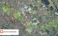
The perifluvial areas census
In 2012 some
perifluvial areas were object of deepen
studies of census. |